

Johns Creek, Georgia, has long embraced innovation in its municipal services. Home to more than 80,000 people in the northern Atlanta metro area, the city has promoted many projects to improve the quality of life for residents, including large-scale redevelopments to create walkable neighborhoods and upgrading utility infrastructure. Recently, city officials applied that forward-thinking approach to communicating with residents about long-term planning.佐治亚州约翰斯克里克市在市政服务方面长期以来一直积极拥抱创新。这座位于亚特兰大地铁区北部、拥有8万多人口的城市,推行了许多旨在改善居民生活质量的项目,包括大规模的重建工程以打造适合步行的社区,以及升级公用设施基础设施。最近,该市官员将这种前瞻性思维运用到了与居民就长期规划进行的沟通中。
With a quickly growing portfolio of active plans affecting everything from transportation and parks to zoning and comprehensive planning, city leaders needed a better way to centralize information, simplify public access, and provide context on policy in both documents and maps. Esri startup partner Konveio had the solution.随着涉及交通、公园、分区规划和综合规划等方方面面的现行计划数量迅速增加,城市领导人需要一种更好的方式来集中信息、简化公众获取途径,并在文档和地图中提供政策背景。Esri的初创合作伙伴Konveio提供了相应的解决方案。
Founded in 2020, Konveio helps community leaders communicate project details with stakeholders from start to finish. Konveio is an ArcGIS technology-connected engagement platform for planners with two flagship offerings: Engagement Hub and Plan Hub. These hubs help cities facilitate public participation, making plans and policy documents easier to access and understand.Konveio成立于2020年,旨在帮助社区领袖自始至终与利益相关者就项目细节进行沟通。Konveio是一个与ArcGIS技术相连的规划师参与平台,拥有两个旗舰产品:Engagement Hub和Plan Hub。这些平台帮助城市促进公众参与,使规划和政策文件更易于获取和理解。

Konveio’s solutions are built to support existing workflows, requiring no special software or training—ideal for staff who typically work with PDFs and ArcGIS Online. The company’s products seamlessly integrate with ArcGIS Experience Builder, enabling geospatial data to interact with policy documents in new and more accessible ways.Konveio的解决方案旨在支持现有的工作流程,无需特殊软件或培训,非常适合通常使用PDF和ArcGIS Online的工作人员。该公司的产品与ArcGIS Experience Builder无缝集成,使地理空间数据能够以全新且更易获取的方式与政策文档进行交互。
Addressing Communication Challenges 应对沟通挑战
Before partnering with Konveio, Johns Creek faced the same challenges common to many other municipalities. Planning documents were hosted as static PDFs across various department webpages, fragmented by topic in a way that was difficult for staff and residents to explore and cross-reference. The content was also dense, jargon-filled, and difficult to navigate.在与Konveio合作之前,约翰斯克里克面临着许多其他市政当局都存在的共同挑战。规划文件以静态PDF的形式存放在各个部门的网页上,按主题分散存放,这使得工作人员和居民难以浏览和交叉参考。而且内容晦涩难懂、充斥着专业术语,也不易查找。
For city staff, answering residents’ routine questions—such as “What new road projects are being planned in my neighborhood?”—required manually searching through multiple documents, which cost time and increased the risk of misinformation. Meanwhile, the city’s GIS data, which was hosted in ArcGIS Online, was not connected with these documents, so spatial insight was rarely meaningfully linked to policy information.对于城市工作人员而言,回答居民的日常问题——例如“我所在社区有哪些新的道路工程计划?”——需要手动查阅多个文档,这既耗费时间,又增加了提供错误信息的风险。同时,该市托管在ArcGIS Online上的地理信息系统数据与这些文档并未关联,因此空间洞察很少能与政策信息建立有意义的联系。
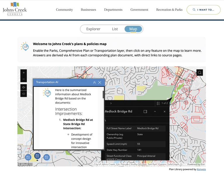
To address these challenges, Johns Creek deployed Konveio’s Plan Hub as a new feature of the city’s website. The hub is fully integrated with Experience Builder, creating an AI-powered, geospatially enabled framework for city plans that is directly embedded into the website.为了应对这些挑战,约翰斯克里克市在其城市网站上部署了Konveio的Plan Hub作为一项新功能。该中心与Experience Builder完全集成,构建了一个嵌入网站的、具备人工智能和地理空间功能的城市规划框架。
Accessible Information for Staff and Residents面向工作人员和居民的可获取信息
The Johns Creek website now features a visually engaging, tile-based layout of adopted plans, each with its own detailed page, glossary, and AI-powered assistant that allows users to ask questions in everyday, nontechnical language, such as “What are the long-term goals for parks in the city?”约翰斯克里克市的网站现在采用了视觉吸引力强的 tile 式布局来展示已通过的规划,每个规划都有自己的详细页面、术语表和人工智能驱动的助手,用户可以用日常的非技术语言提问,例如“该市公园的长期目标是什么?”

“Konveio has made our city plans more accessible,” said Jennifer Chapman, senior communications manager at the City of Johns Creek.“Konveio让我们的城市规划更易于理解,”约翰斯克里克市高级传播经理詹妮弗·查普曼说。
Konveio’s Explorer view allows users to search across all plans at once or filter by status, like “adopted” or “draft,” and provides results with clickable page references. For example, when searching for parking policies, the platform identifies which plans contain relevant policies—such as the Transportation Master Plan and the Recreation and Parks Master Plan—while clearly showing which documents are not relevant to prevent user confusion. The AI assistant pinpoints where each policy is mentioned and generates concise summaries to help users quickly grasp key takeaways. In a pop-up window, users can then click on links to open the source pages in the document, streamlining navigation and reducing the time it takes to find precise information.Konveio的浏览视图允许用户一次性搜索所有规划,或按状态(如“已采用”或“草案”)进行筛选,并提供带有可点击页面引用的结果。例如,在搜索停车政策时,该平台会识别哪些规划包含相关政策(如交通总体规划以及娱乐和公园总体规划),同时清晰显示哪些文件不相关,以避免用户混淆。人工智能助手会精准定位每个政策被提及的位置,并生成简洁的摘要,帮助用户快速掌握关键要点。在弹出窗口中,用户可以点击链接在文档中打开源页面,从而简化导航并减少查找精确信息所需的时间。
It is Konveio’s integration with Experience Builder, however, that represents the biggest transformation for Johns Creek. This is how Konveio redesigns planning communication so that, instead of being a document-based process, it is a spatially informed decision-making support tool.然而,正是Konveio与Experience Builder的整合,为约翰斯克里克带来了最大的变革。这就是Konveio重新设计规划沟通的方式——使其不再是一个基于文档的流程,而是一个具备空间信息的决策支持工具。
By embedding Konveio into an Experience Builder app, Johns Creek allows users to interact with a citywide map layered with GIS data, including information such as park locations, zoning districts, or bike lanes, and instantly retrieve related planning policies. When a user clicks on a location like Cauley Creek Park, that triggers Konveio’s AI-powered map function. The system automatically surfaces excerpts from the Recreation and Parks Master Plan that relate to that specific park, including details about its development phases, short- and long-term goals, and direct links to supporting documentation.通过将Konveio嵌入到Experience Builder应用程序中,约翰斯克里克允许用户与一个叠加了GIS数据的全市地图进行交互,这些数据包括公园位置、分区、自行车道等信息,并能即时检索相关的规划政策。当用户点击像考利溪公园这样的地点时,会触发Konveio的人工智能地图功能。该系统会自动显示《娱乐与公园总体规划》中与该特定公园相关的摘录,包括其发展阶段、短期和长期目标的细节,以及支持性文件的直接链接。
Because Konveio’s AI search is connected to both document content and GIS layers, it acts as a real-time bridge between spatial data and narrative policy. It doesn’t just show a location; it also explains the “why” behind the planning decisions made for that location.由于Konveio的人工智能搜索同时关联了文档内容和地理信息系统图层,它成为了空间数据与叙述性政策之间的实时桥梁。它不仅展示一个位置,还会解释针对该位置所做规划决策背后的“原因”。
“Integrating with ArcGIS lets us explain planning decisions in a spatial context, which shows residents exactly what’s planned for their community—and why it matters—without them having to dig through dense documents,” said Chapman. “Our communication is clearer, faster, and a lot more helpful.”查普曼说:“与ArcGIS集成使我们能够在空间背景下解释规划决策,这能向居民准确展示为他们社区制定的规划内容以及其重要性,而无需他们费力查阅冗长的文件。我们的沟通变得更清晰、更快捷,也更有帮助。”

Furthermore, the system is adaptive. As staff update GIS layers or upload new versions of planning documents to Konveio, the integrations update automatically. This ensures that the map always reflects the latest data and insight without requiring manual syncing—a major time-saver for the city’s IT and planning departments.此外,该系统具有适应性。当工作人员更新地理信息系统图层或向Konveio上传新版规划文件时,集成会自动更新。这确保了地图始终反映最新的数据和见解,无需手动同步——这为该市的信息技术和规划部门节省了大量时间。
Enhancing Communication and Trust 增强沟通与信任
Johns Creek’s new Plan Library has significantly enhanced public access to complex planning materials. Residents can now quickly find relevant information without scrolling through entire PDFs or calling city staff. The AI assistant reduces information barriers, and glossary features help decode jargon for everyday users. Translated versions of documents support inclusivity, ensuring that more residents can engage meaningfully with the content.约翰斯克里克新建的规划图书馆极大地提升了公众获取复杂规划材料的便利性。居民如今无需滚动浏览整个PDF文件或致电市政工作人员,就能快速找到相关信息。人工智能助手减少了信息获取障碍,术语表功能则帮助普通用户理解专业术语。文档的翻译版本有助于促进包容性,确保更多居民能够切实参与到内容互动中。
From the administrative side, the city gains visibility into what questions residents are asking, helping staff tailor future documents, FAQs, and community engagement efforts. Staff also spend less time fielding repetitive questions and cross-referencing plans, freeing them up to focus on higher-value work.从行政层面来看,该市能够了解居民所提出的问题,这有助于工作人员定制未来的文件、常见问题解答以及社区参与计划。工作人员也能减少花在处理重复问题和交叉参考计划上的时间,从而得以专注于更具价值的工作。
Perhaps most critically, the Experience Builder integration has turned spatial exploration into an educational tool. By tying policy content to locations, Johns Creek helps residents understand not only what is planned but also why and where—boosting transparency and building public trust in the city’s plans for the future.或许最为关键的是,体验构建器的整合已将空间探索转变为一种教育工具。通过将政策内容与具体地点相关联,约翰斯克里克不仅帮助居民了解规划的内容,还让他们明白规划的原因和地点——这提高了透明度,并增强了公众对该市未来规划的信任。


没有回复内容