
由GIS驱动的公共交通

After 20 years in public transit and now at Esri, I still believe location is the golden thread that connects all of our great work across departments. It can transform how agencies deliver their promise of safe, reliable service. Every day of service, transit finds a way—or makes one—to serve communities in an increasingly complex environment. To keep pace, agencies must elevate operations with location intelligence, through GIS: not just maps, but an enterprise strategy that unites departments, breaks down silos, and drives measurable outcomes.在公共交通领域工作了20年后,我现在任职于Esri。我依然认为,位置信息是串联各部门出色工作的金线。它能够改变机构履行安全、可靠服务承诺的方式。在每一天的运营中,公共交通总会找到办法——或者创造办法——在日益复杂的环境中为社区提供服务。为了跟上节奏,各机构必须借助地理信息系统(GIS),利用位置智能提升运营水平:这不仅仅是地图,更是一种企业战略,能够联合各部门、打破壁垒,并推动可衡量的成果达成。
Transit agencies continue to face growing challenges: aging assets, workforce shortages, shifting ridership patterns, severe weather and natural disasters, and rising expectations for real-time customer information and to keep service intact. These all require decisions that draw from multiple data sources. Too often, those data live in fragmented systems. When decision makers must stitch together siloed information, key patterns and relationships get missed which impact the decisions being made.公交机构持续面临着日益严峻的挑战:资产老化、劳动力短缺、客流量模式变化、恶劣天气与自然灾害,以及公众对实时客户信息和保持服务不间断的期望不断提高。所有这些都需要依据多个数据源来制定决策。然而,这些数据往往存在于分散的系统中。当决策者必须整合这些孤立的信息时,关键的模式和关联就会被遗漏,进而影响所做出的决策。
Imagine what your agency could look like and how it could function, if it were fully integrated. It truly is possible – with the help of GIS! GIS is no longer just a cartography tool. When adopted as an enterprise approach, location intelligence becomes the connective tissue across departments so teams can work from the same authoritative geography and contextual data. That unlocks faster, smarter decisions and better outcomes for riders and other important stakeholders.想象一下,如果你的机构实现了完全整合,它会是什么样子,又能如何运作。借助地理信息系统(GIS),这一切真的有可能实现!地理信息系统不再仅仅是一种制图工具。当它被用作一种企业级方法时,位置智能就成为了各部门之间的连接纽带,这样各个团队就能基于相同的权威地理信息和背景数据开展工作。这将为乘客和其他重要利益相关者带来更快速、更明智的决策以及更好的结果。
Currently, many transit agencies use GIS, but just for route planning and performance analysis. However, the potential benefit of a geospatial approach extends far beyond that. In fact, any department can leverage GIS for its unique challenges and opportunities. For example, your HR team can utilize GIS for workforce planning, using demographic data to understand where employees live and how best to serve them. They can also benefit from understanding where to find potential employees, and can create targeted recruitment strategies that reflect community needs and demographics.目前,许多公交机构都在使用地理信息系统(GIS),但仅用于路线规划和绩效分析。然而,地理空间方法的潜在益处远不止于此。事实上,任何部门都可以利用GIS来应对其独特的挑战和机遇。例如,人力资源团队可以借助GIS进行劳动力规划,利用人口统计数据了解员工的居住地以及如何最好地为他们提供服务。他们还能从了解潜在员工的来源地中获益,并制定能反映社区需求和人口特征的针对性招聘策略。
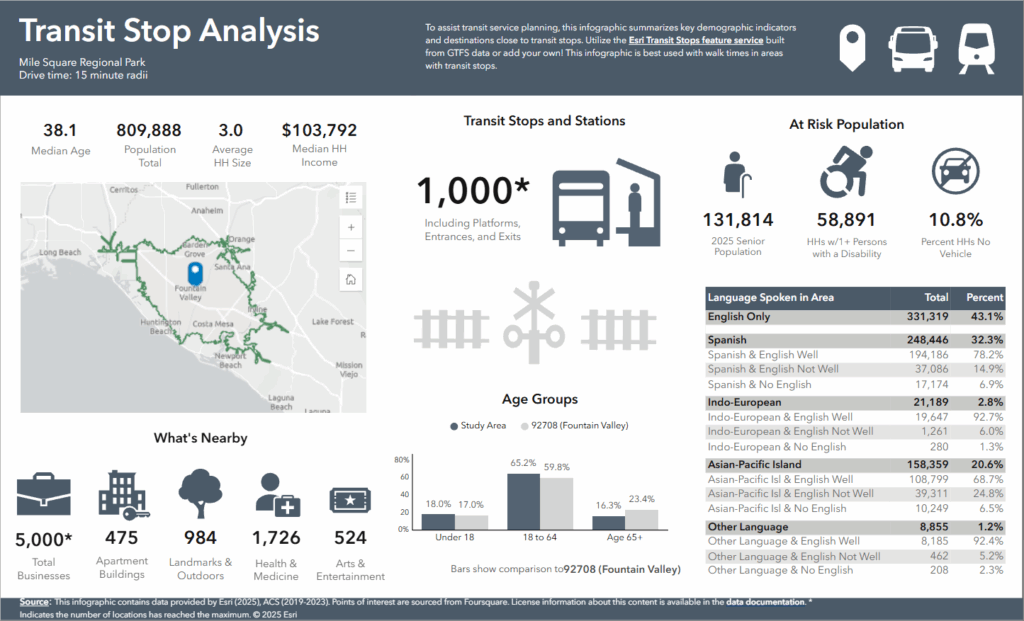
![图片[1]-由GIS驱动的公共交通-ArcGIS论坛-软件-CityEngine城市引擎](https://www.esri.com/en-us/industries/blog/wp-content/uploads/2026/01/transitinfo1-1024x621.png)
During an emergency – a wildfire, an earthquake or a hurricane, GIS can support viewing and selecting affected employees on a map that concurrently shows real time event data, making it easier to proactively support your workforce. This is what GIS can do for you today, truly only limited by your imagination. GIS is a strategic initiative that positions transit agencies at the forefront of innovation with one platform.在紧急情况下——比如野火、地震或飓风发生时,地理信息系统(GIS)能够支持在地图上查看和筛选受影响的员工,同时该地图还会显示实时事件数据,这让主动为员工提供支持变得更加容易。这就是地理信息系统(GIS)如今能为你所做的,其作用实际上只受限于你的想象力。地理信息系统(GIS)是一项战略举措,它借助一个平台,将公交机构置于创新的前沿。
In my time as a GIS professional, I’ve witnessed – and driven – the amazing ability of GIS to transform transit. However, I’ve learned no clearer lesson than this: a successful enterprise GIS requires more than technology; it needs a culture that values cross-department collaboration, shared authoritative data, and continuous learning. This sometimes requires a cultural shift —one that embraces innovative thinking and recognizes the importance of location intelligence. This also involves increasing geospatial competence and helping individuals understand how geographic data can benefit not just their own work but the agency as a whole. We’ve made good progress in changing the understanding of GIS over the years, but there is still plenty of work to do.在我作为地理信息系统(GIS)专业人士的职业生涯中,我亲眼见证并推动了GIS在改变公共交通方面的惊人能力。然而,我得到的最深刻的教训是:一个成功的企业级GIS不仅需要技术,还需要一种重视跨部门协作、共享权威数据和持续学习的文化。这有时需要一种文化转变——一种拥抱创新思维并认识到位置智能重要性的转变。这还包括提高地理空间能力,帮助人们理解地理数据不仅能对他们自身的工作有益,还能对整个机构带来好处。多年来,我们在改变人们对GIS的理解方面取得了不错的进展,但仍有大量工作要做。
The mantra of “good data, better technology, best practices” can guide transit agencies toward embracing GIS as a fundamental tool. When there are too many systems to consult, especially when a decision needs to be made quickly, the risk of missing something critical increases exponentially. With Esri’s enterprise approach, GIS can be integrated seamlessly into operations, allowing for the analysis of vast data sets in real time. This capability provides the foundation for making smarter, data-driven decisions that prioritize public service.“优质数据、更优技术、最佳实践”这一准则能够指引公交机构将地理信息系统(GIS)作为核心工具来运用。当需要参考的系统过多时,尤其是在需要快速做出决策的情况下,遗漏关键信息的风险会急剧增加。借助Esri的企业级解决方案,地理信息系统可以无缝融入日常运营,从而能够实时分析海量数据集。这种能力为制定更明智、以数据为导向且以公共服务为优先的决策奠定了基础。
As we look ahead, the need for transit agencies to adapt and evolve has never been more pressing. Rethink the business model of transit around a geospatial framework that drives innovation, equity, and operational resilience. Start with the 3-step pilot above, track one clear metric, and expand once you prove value. GIS can be the backbone that enables smarter, customer-centered decisions across your agency.展望未来,公交机构比以往任何时候都更迫切地需要适应和发展。围绕地理空间框架重新思考公交的商业模式,以推动创新、公平和运营韧性。从上述三步试点开始,跟踪一项明确的指标,一旦证明其价值就进行扩展。地理信息系统(GIS)可以成为支撑整个机构做出更智能、以客户为中心的决策的支柱。
By harnessing location intelligence, my dear transit colleagues, we can find a way or make one as the quotation encourages, rethinking the business model of transit around a geospatial framework that drives innovation, equity, and operational resilience. GIS can be the backbone that enables smarter, customer-centered decisions across your agency.亲爱的公交同仁们,正如那句名言所鼓励的,通过利用位置智能,我们总能找到方法,或者创造方法。我们可以围绕一个推动创新、公平和运营韧性的地理空间框架,重新思考公交的商业模式。地理信息系统(GIS)可以成为支撑你们机构做出更智能、以客户为中心的决策的支柱。
Good data, better technology, best practices—for all. That’s where our journey with GIS will take us, ensuring that transit services continue to deliver.优质的数据、更先进的技术、卓越的实践——为所有人服务。这就是我们借助地理信息系统(GIS)踏上的征程,它将确保公共交通服务持续提供。
Let’s go, transit! 出发吧,公交系统!


没有回复内容